Turn any standard tripod into a stable, non-magnetic, compass-safe navigation station for orienteering, camping, hiking, backpacking.
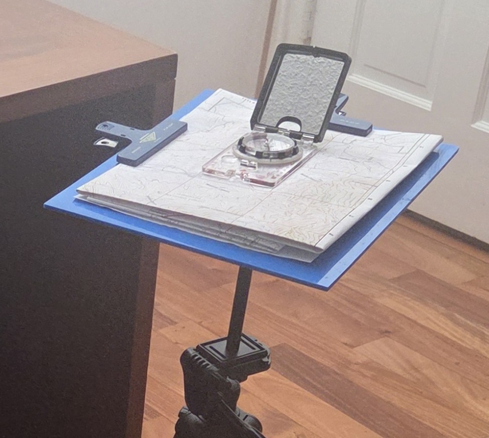
The Map-Table™ Premium Tripod Mount delivers a stable, non-magnetic, compass-safe working surface so you can take accurate bearings and navigate with confidence in the field. No more struggling to hold the map and compass, hunting for a non-magnetic surface, or fighting uneven ground. It attaches quickly to most standard tripods, giving you a reliable platform anywhere, indoors or out, at any convenient height.
Originally developed for Boy Scout orienteering, this hand-crafted, lightweight, fully non-magnetic system is ideal for Scouts, trainers, hikers, backpackers, and outdoor enthusiasts. It includes two strong “Penco Clampy” clips to securely hold your map while you locate positions, take bearings, measure distances, and calculate paces; and a compass pouch to keep things together.
Typical Uses
- Accurately and consistently complete an orienteering course.
- Draw bearing lines, get coordinates and calculate paces to destinations for orienteering or training, accurate to within 1° with care.
- Accurately sight objects in the distance at specific bearings.
- Find and mark your exact location on a topo map using landmarks or GPS.
- Leave set up at camp for reference and training.
- Take on a hike or backpacking trip to find location, bearings and direction.
- Use at meetings, merit badge training, gather around for orienteering training.
- Use as a device to increase interest and focus in map and compass work.
- Use as a convenient, reliable, non-magnetic working surface anywhere.
- Gift an orienteering enthusiast, award your Scout or Troop.


Key Features
- 9.5″ × 12″ blue marine-grade HDPE Map-Table surface. Will not warp or degrade in the sun.
- Rugged black ABS adapter permanently bonded to the Map-Table with precision ¼”-20 insert.
- 6″ anodized aluminum removable extension rod included to prevent magnetic interference from ferrous tripod heads.
- Tough, impact-resistant, and fully weatherproof — withstands drops, rain, extreme heat, cold, and UV exposure.
- Lightweight (≈ 20.5 oz) yet stable enough for dependable long-term field use.
- Includes two repositionable Penco Clampy map clips.
- Includes a storage pouch for compass and accessories, and a drawstring bag for the complete system.
How It Works
- Screw the bottom end of the extension rod to a tripod’s quick-release plate, if available.
- Screw the top end of the extension rod into the Map-Table.
- Attach the Map-Table to the tripod.
- Secure your map or notes with the Penco clips.
- Move the tripod legs to orient the map and compass.
- Enjoy – Use the Map-Table to find locations, take bearings, measure distances, calculate paces, etc.
- See below for Tips and Tricks.
Frequently Asked Questions
- What is a Map-Table used for? The Map-Table turns any standard tripod into a stable, non-magnetic, compass-safe navigation station for orienteering, camping, hiking, and backpacking. Use it to locate positions, take bearings, measure distances, and calculate paces – in the field, at camp, or at meetings and merit badge training.
- Will a tripod mess up my compass reading? The included 6″ anodized aluminum extension rod provides sufficient separation from the tripod head for reliable magnetic isolation on most modern tripods. On rare, heavily ferrous tripods (such as some older all-steel models), interference may still occur, so it’s a good idea to test the Map-Table on any new tripod – see Testing for Magnetic Interference, below.
- What kind of tripod do I need for the Map-Table? The Map-Table works with most modern tripods that have a 1/4″-20 threaded interface. For maximum stability, choose a tripod with a rectangular quick-release plate, and avoid inexpensive ball-headed tripods, tripods with legs that splay under pressure, and full-metal tripods – see Related Products, below, for recommendations.
- How accurate are bearings taken on the Map-Table? With care, you can draw bearing lines and calculate paces to destinations accurate to within 1°. Most any compass will be accurate enough for table use; just remove watches, rings, and other metal jewelry before taking a bearing.
- How much does the Map-Table cost and where can I buy it? The Map-Table is $75 with free shipping. Order at eBay, Etsy, or Amazon, or email support at map-table.com for more information.
- Is the Map-Table weatherproof? Yes – it’s tough, impact-resistant, and fully weatherproof, and withstands drops, rain, extreme heat, cold, and UV exposure. Our test Map-Table sat outside through an entire Tucson Summer without warping or degrading.
- What comes in the box? The 9.5″ × 12″ blue marine-grade HDPE Map-Table with bonded ABS tripod adapter, a 6″ anodized aluminum extension rod, and two repositionable Penco Clampy map clips. It also includes a compass pouch (with four grip dots) for the clips, rod, and accessories, and a nylon drawstring bag for the complete system.
Ready to Order?
- Order at eBay
- Order at Etsy
- Order at Amazon
- Price: $75 with free shipping
- Email support at map-table.com for more information.
Tips and Tricks
Setting up the Tripod
- For maximum stability, choose a tripod with a rectangular quick-release plate. Avoid inexpensive ball-headed tripods (too hard to tighten), tripods with legs that splay under pressure, and full-metal tripods (too magnetic) – see Related Products (below) for recommendations.
- Leave the neck down and adjust height with the legs only. Use the widest leg spread possible.
- Set up, level, and tighten the tripod before attaching the Map-Table.
Attaching the Extension Rod & Map-Table
- If the tripod has a quick-release, screw it tightly onto the extension rod, so it won’t slip (leave it attached for convenience).
- Screw the extension rod firmly into the Map-Table, hand-tight plus a little extra so it won’t slip.
- Attach the unit to the tripod. If the Map-Table is loose, hold the rod and twist the table until tight, and re-tighten it to the tripod if necessary.
- Depending on the tripod, the table may “give” a bit when pressed around the edges but should return to level when released.
Orienting the Map
- Fold maps as flat and even as possible for the best working surface, and/or drape over one edge. Pre-folded maps are nice, like these at mytopo.com.
- Position the two Penco clips to hold the map securely (usually at the top and on one side).
- Remember to remove watches, rings, and other metal jewelry before taking a bearing. Avoid leaning over the map with metal zippers, buttons, or buckles close to the compass.
- Set the compass, then orient the map – align it to North. If the tripod doesn’t have a panning knob to turn the map, gently shift the tripod right or left by the legs or extension rod instead.
Working with the Map-Table
- If you can, choose a compass that has grips (little silicone feet) to hold the compass in place more easily, minimizing give from pressure on the Map-Table. Otherwise, apply the four “grip dots” included in the Compass pouch to the bottom corners of the compass.
- If the compass bezel doesn’t easily turn, apply a little powdered graphite, a few drops of mineral oil, or silicone lube between it and the baseplate. You should be able to easily hold the compass in place with one or two fingers, without pressing down hard, while turning the bezel with the other hand.
- “Work the compass” – keeping palms off the table, use a few fingers on one hand to hold the compass in place, then turn the bezel with the other hand.
- Or “work the table” – keep the table balanced with palm(s) and fingers across the table center. Position the compass with both hands, then hold it in place with a few fingers on one hand while turning the bezel with the other hand.
- Or “support the table” – use a few fingers on or underneath the edges to support the table while holding the compass in place with one hand, then turn the bezel with the other hand.
- Use the table to hold the compass steady while taking bearings or sighting objects in the distance.
Related Products
- Entry Level Tripod – $25: NEEWER Entry Level Version Tripod. Inexpensive, reasonably stable, lightweight (20 oz.), plastic-headed basic tripod with a rectangular quick-release plate. Easy leg adjustment and good height. The rubber pad on the quick-release may be removed.
- Premium Tripod plus Ball Head – $200: Manfrotto MT055XPRO3 Aluminum Tripod plus Vanguard Alta BH-250 Ball Head. More expensive, very stable, not lightweight (6.77 lbs.) and therefore not very portable. It has a nice panning control to smoothly turn and orient the map.
- Entry level compass: Brunton Nexus 7DNL Compass Inexpensive, no grip dots.
- Premium compass: SUUNTO MC-2 Compass: Top-of-The-line Compass for Professionals & serious Hikers. Smooth bezel, grip dots, sight mirror, inclinometer.
- Grip Dots – Cabinet Bumpers Soft Self-Adhesive Clear Rubber – $8 Additional or replacement grip dots for compass feet, to keep a compass from slipping around making it easier to hold in place.
- Penco Plastic Clampy Clip – Navy – $4 Extra or replacement clips for the Map-Table.
Notes on Product Design
- The HDPE Map-Board: HDPE was chosen as the best surface material for our outdoor use. G10/FR4, for instance, is heavier, sharper, and more brittle than HDPE. Other materials warp and degrade in sunlight over time, like PA6, Nylon, Polycarbonate, and PET-G. HDPE has “character” – it may have swirls, splotches, or blade lines in its otherwise shiny surface, and may have a very slight bow, but is by far the friendliest overall choice. Our test Map-Table sat outside through an entire Tucson Summer without warping or degrading.
- The ABS Tripod Adapter: ABS was selected for the optimal balance of rigidity, weight, and bonding performance. At 12mm thickness it provides a strong, stable mounting base for the brass insert. It epoxy-bonds exceptionally well to marine-grade HDPE using 3M DP8005, and maintains excellent dimensional stability in outdoor conditions.
- The 1/4″-20 Brass Heat Set Insert: Chosen for its excellent holding power in thin-wall ABS, the short brass insert with aggressive knurling provides a strong, reusable 1/4″-20 threaded mount while keeping weight and profile low. It delivers reliable torque resistance for repeated extension rod or tripod attachment while remaining fully non-magnetic. It seats cleanly and leaves a slightly-exposed flange to provide surface friction for the extension rod or tripod.
- The 6″ Anodized Aluminum Extension Rod: The extension rod is included to provide sufficient separation between the Map-Table and the tripod head, ensuring reliable magnetic isolation for accurate compass readings on most tripods.
- The Map Clips: The two Penco Plastic Clampy Clips provided hold are lightweight, non-magnetic, repositionable, unobtrusive, and do well in the sun. They have serrated teeth and are strong and wide enough for a good grip on map materials. The small metal spring in the handle does not affect the compass.
- The Compass Pouch: A 10” x 7” 3-ring binder pouch is provided to pack the map clips and extension rod. It’s big enough to hold the compass, rulers, pens/pencils and other accessories as well.
- The Storage Bag: The whole unit is stowable and packable in the provided 12×16″ nylon drawstring bag, along with a lightweight tripod if desired.
- Compasses: Most any compass will be accurate enough for table use. More expensive compasses have more features, like a sighting mirror or inclinometer, are easier to turn, and are sturdier overall. Try to pick a compass with “grips,” little rubber feet to keep the compass from sliding. Use some powdered graphite or a few drops of mineral oil to make the bezel easier to turn. See Related Products, above for compass suggestions.
- Tripods: The Map-Table works with most modern tripods that have a 1/4″-20 threaded interface. Less-expensive plastic-headed tripods introduce some flex or “give” to the Map-Table when pressing around the edges. Aluminum and carbon-fiber tripods are more robust; but are larger, heavier, and are therefore less portable. See Related Products, above for tripod suggestions.
Repairing the Map-Table
The Map-Table is made with marine-grade HDPE, which is tough and resilient, but if it gets dropped or knocked over and the edge become chipped or rough, lightly sand it with 220-grit sandpaper until smooth. Wipe the surface clean with isopropyl alcohol.
If the extension rod needs to be replaced for any reason, or any other problem arises, let us know – send an email to support at map-table.com.
Testing for Magnetic Interference

It’s a good idea to test the Map-Table on any new tripod for magnetic interference. The included 6″ aluminum extension rod provides sufficient magnetic isolation for most modern tripods. On rare, heavily ferrous tripods (such as some older all-steel models), magnetic interference may still occur.
- Set a map (or lined paper or graph paper) on the Map-Table.
- Set the compass to magnetic North, with 0° straight up.
- Place the compass edge along a vertical line at the near bottom corner of the map, then turn the Map-Table until the compass needle aligns with 0°, so everything is now aligned magnetic North.
- Move the compass a few inches up along the same vertical line. The compass should still point to 0°. Continue up the vertical line the length of the map. The compass should always still point to 0°.
- Repeat on a vertical line toward the middle, starting at the bottom to the top; and repeat on the far side. I usually test it at nine points (lower, middle, and top; left, center, and right).
- If the compass does seem to deflect from 0° at any point, repeat testing to confirm the deflection – above, below, and side-to-side. Double-check there is no metal jewelry, button or buckle nearby.
- If it continues to deflect, there must be magnetic interference. If necessary, use a different tripod such as one of those recommended above; contact support at map-table.com for further assistance.
- You can test a specific object for magnetic interference. Place it underneath the table, just beneath the compass, and run it a back and forth a few inches. Note if the compass deflects at all. Then lower it a few inches beneath the table and repeat until you find it is far enough away to be safe.
Orienting a Map

Typically you’ll want to orient your map to True North. To do this, we will offset the compass from 0° a little to account for the difference between True North and Magnetic North, then rotate the Map-Table to Magnetic North, leaving the map oriented to True North.
- Find the magnetic declination on the map margin (e.g., “12°E” or “10°W”). This is the degree to which Magnetic North varies from True North at this location. The “Agonic line,” where Magnetic North and True North are identical, runs north to south down through the Eastern third of the United States. West of that line, a compass points East of True North so that is called East declination; East of that line, a compass points West of True North so that is called West declination.
- Rotate the compass bezel by the declination amount from 0° — subtract East declination (e.g. to 348° – remember, “East is least”) or add West declination (e.g. to 10°)
- Place the compass edge along a North-South grid line on the map, with the direction-of-travel arrow pointing North.
- Rotate the Map-Table until the magnetic needle sits inside the orienting arrow (“red-in-the-shed”). If the tripod doesn’t have a panning knob to turn the map, gently shift the tripod right or left by the legs or extension rod instead.
- The compass now points to Magnetic North, while the map is oriented to True North. Now you can use the Map-Table to find locations, bearings, plan routes, calculate distance, paces, travel times, and so on.
map-table.com